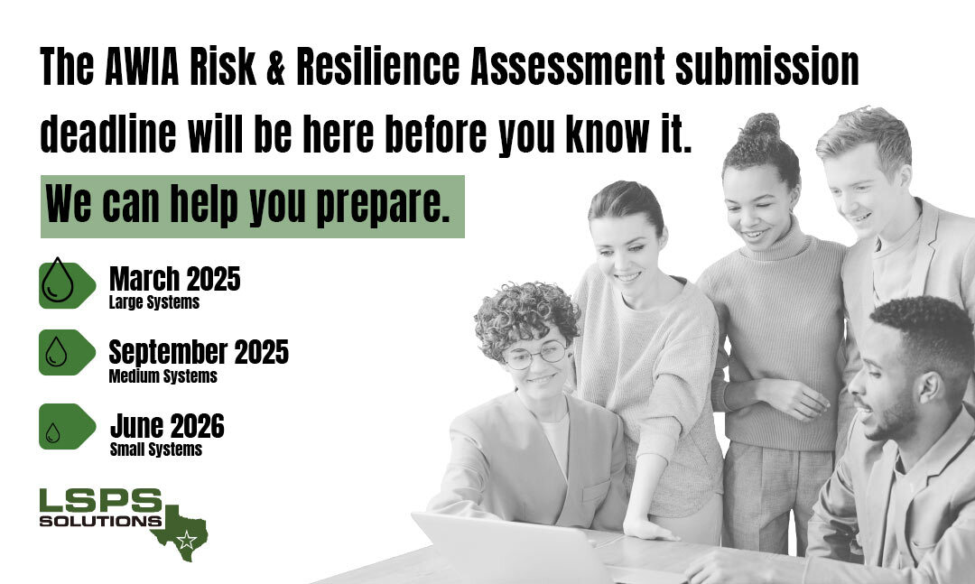
Asset Management

“Asset management has become a public sector buzzword. We hear about it on an almost daily basis. But what does it really mean?”

Asset Management

“Asset management has become a public sector buzzword. We hear about it on an almost daily basis. But what does it really mean?”

From our perspective asset management is all about identifying your system’s assets, knowing exactly where they are located and knowing the current condition of those assets so that we can properly operate, maintain, and replace them in a timely manner.

LSPS Solutions, LLC provides a variety of asset management tools that will identify your system’s assets, collect location and other important data about those assets, and then make that information readily available in a variety of formats so that it can be used for planning activities.

banner
Electronic O&M Manuals
An electronic O&M Manual is an asset management tool that puts all of the information about a specific asset, (like a water or wastewater plant, lift station, or pumping facility), in one, easy to access, location on the network so that it can be conveniently accessible to anyone having the security clearance to access it.

These electronic O&M Manuals are constructed using .html programming so that they can be accessed using your computer’ s internet browser; so, no expensive, third-party software is required. The manuals typically contain information about the asset, photos, pump curves, links to construction drawings, links to submittal data, maintenance and troubleshooting information.

Mapping & GIS Projects
Accurate maps are crucial to the management of public infrastructure. LSPS Solutions can provide a variety of mapping solutions, including Google Earth .kmz files and GIS shapefiles. Using sub-meter accuracy, (or in some cases sub-centimeter accuracy), Trimble GIS receivers, LSPS Solutions technicians can collect GPS coordinates and other valuable information on appurtenances within your system and then map that data and make it available in an electronic format so that it can reside on your network and be readily accessible. Using Google Earth and/or GIS software, the data can be geo-spatially tied to the map location so that the data can be viewed just by clicking on the appurtenance. Using satellite imagery, these maps can be used to accurately measure distances, which makes locating the assets in the field quick and easy.

Aerial Surveying/Photography/Inspection
The use of drones (UAVs) can be a cost effective and exceptionally reliable method of gathering data. UAVs can be used to inspect and capture photographs of infrastructure that is not readily accessible, and they can be used to create accurate survey quality orthomosaic photos for mapping and engineering design plans. An orthomosaic image is a number of photos stitched together and geometrically corrected such that the scale is uniform, and the photo has the same lack of distortion as a map.

Water/Wastewater Facility Assessments
In order to develop a plan for rehabilitating and replacing water and wastewater facilities, LSPS Solutions performs assessments of these facilities to determine the current condition of the facilities’ major components. To accomplish this, our field technicians visually inspect and collect data and photographs of all the major equipment, controls, piping and structures at each of the facilities. we also list defects and TCEQ rule violations observed during the inspection and make a determination, based on those observations, of the condition of each of the major equipment components.

Upon completion of the field inspections, we gather and record any additional information that is readily available for each of the specific equipment components, i.e. pump curves, manufacturers brochures, etc. and export all the pertinent data from the GIS file into an Excel spreadsheet.

Street Inventories (Pavement Assessments)
The Street Inventory is a data collection and pavement assessment tool used to assign a score or rating to each street segment. The method used in the development of the Street Inventory is derived from a publication of the Asphalt Institute – A Pavement Rating System for Low-Volume Asphalt Roads, Asphalt Institute Information Series No. 169) and is based on visual criteria. The rating system establishes a maximum value of 100 for a newly constructed street. As the street ages and deteriorates, the condition rating decreases.

The data collected and established during the process is then recorded and assimilated into a report. The report is designed to be an administrative tool for the City Council and staff to use when making decisions about street rehabilitation and repair and the funding of these projects.

In order to effectively communicate the results of the pavement assessment, the data is sorted and displayed in a variety of formats.

Traffic sign Inventories
Most municipalities have a huge investment in their street and traffic control signs, yet they know very little about how many they have, where they have them and what the condition of them is. Without knowing this information, it is very difficult to develop a plan for ongoing maintenance and replacement of the signs.

Fortunately, this is one of the asset management tools that LSPS Solutions, LLC specializes in. We can prepare a sign inventory for your city and provide you with a Google Earth .kmz file with precise locations (sub-meter accuracy) of all signs and a list of attributes for each of the signs including photos and a condition value. In addition to the Google Earth file, you would receive a GIS shape file with the same precise locations of all the signs and a data dictionary that includes all of the relative data about those signs and an Excel spreadsheet with all of the information about the signs that will enable you to sort the data and, thereby create a plan for ongoing sign replacement.

What They’re Saying About Us

Contact us today to speak with our experienced team

Call 361.212.8243 or Schedule a Consultation

Call Now Button